Overview
The Land Use Plan is a provincially-approved document that enables implementation of the long-term vision for growth and change of the physical campus: Campus Vision 2050.
Vision: In 2050, the campus is a unique combination of world class teaching, learning, and research and thriving campus neighbourhoods—a resilient, climate-neutral, urban campus that embraces accessibility, inclusivity, and meaningful reconciliation with Indigenous peoples, while celebrating and honouring its unique history and the land and ecosystem that support it.
Download the UBC Land Use Plan
Key Components of the Land Use Plan
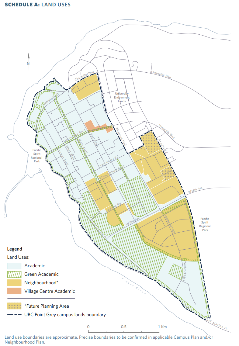
Land Uses and Boundaries
- Three main land uses:
- Academic (teaching, research, and other, including student housing),
- Green Academic (open areas that support land-based teaching, research, etc), and
- Neighbourhoods (providing a range of rental and long-term lease housing, amenities and services).
Housing Choice and Affordability
- Supporting UBC’s Housing Action Plan commitments to increase housing choice and affordability, including market and below-market rental targets, and preserving land capacity for student housing expansion.
Amenities
The amount and types of amenities to support population growth, including community spaces, health services, schools, daycares, commercial centres, partnership space and more.
Open Space
Amount, features and access to open spaces such as public green spaces, greenways, green edges, courtyards, parks, forested and natural areas, and community gardens to enhance Musqueam presence, support health and wellbeing and help create resilient natural systems.
Biodiversity and Ecology
Commitments to identify, enhance and manage campus ecology and biodiversity including tree canopy coverage, green infrastructure and nature-based solutions for rainwater management, climate adaptation and mitigation, and enhancing species diversity and soil conditions.
Mobility and Accessibility
Improving transportation to, from and around campus including integrating future SkyTrain, measures to promote use of active and sustainable modes of transportation, and development of a more equitable and accessible transportation system.
Climate and Resilience
Supporting climate action and resilience including: operational greenhouse gas emission reductions and working toward targets in existing plans such as, the updated Rainwater Management Plan, the Green Building Action Plan and the Water Action Plan.
Infrastructure and Servicing
Infrastructure (streets, energy, water, rainwater runoff, sewers, waste, etc.) commitments include fiscally responsible management of existing and proposed infrastructure, ensuring infrastructure is safe, secure and sustainable, and prioritizing infrastructure investments and resources in areas of growth.
Updates to the Land Use Plan
A major amendment to UBC’s Land Use Plan (LUP) was adopted by the Province in July 2024. The amendments to the Land Use Plan were determined through the Campus Vision 2050 public engagement and planning process. This is the first major update to the Plan since 2011, bringing it into alignment with Metro Vancouver’s 2050 Regional Growth Strategy and Translink’s Transport 2050.
UBC’s amended Land Use Plan commits to a review every five years to respond to evolving community needs, conditions and opportunities. UBC engages the community in a Land Use Plan amendment process when changes are required.
UBC’s Board of Governors approves detailed policies to carry out the Land Use Plan’s vision. On academic lands, the Vancouver Campus Plan policies guide development. These policies include more student housing, improving outdoor spaces, and using the campus as a living laboratory.
In campus neighbourhoods, UBC’s Board of Governors approves Neighbourhood Plans to guide residential development. These Plans include specific policies for features like park space, recreation, transportation and building height.
UBC Land Use Plan Timeline
1997
UBC Official Community Plan adopted
The predecessor of the Land Use Plan
2000
Memorandum of Understanding signed with Metro Vancouver
UBC signed MOU regarding neighbourhood planning
2001
Hawthorn Neighbourhood Plan adopted
Neighbourhood construction now complete
2001
Chancellor Place Neighbourhood Plan approved
Neighbourhood construction now complete
2004
East Campus Neighbourhood Plan approved
Neighbourhood construction now complete
2004
U Boulevard Area Plan approved
Area construction is ongoing
2005
Wesbrook Place Neighbourhood Plan approved
Neighbourhood construction is ongoing
2010
UBC Land Use Plan adopted
Replaced the Official Community Plan
2010
UBC Vancouver Campus Plan approved
Replaced the 1992 Main Campus Plan
2011
UBC Land Use Plan amended
Wesbrook Place Neighbourhood Plan also amended
2011
UBC Land Use Plan amended
Shifted development from UBC Farm to Wesbrook Place
2015
UBC Land Use Plan amended
To include a Regional Context Statement
2016
Wesbrook Place Neighbourhood Plan amended
To enable new forms of development and urban design
2017
Stadium Neighbourhood planning process
The timing and proposed form of development of the future Stadium Neighbourhood will be considered and adjusted in the context of the long term vision for the campus.
2024
Campus Vision 2050 & Amended Land Use Plan
The Province of BC has adopted an amended Land Use Plan for the UBC Vancouver campus, enabling the university to begin implementing the ideas and strategies developed with the community through Campus Vision 2050 - which along with the Housing Action Plan was approved by the UBC Board of Governors in December 2023.