Connected Campus

Image
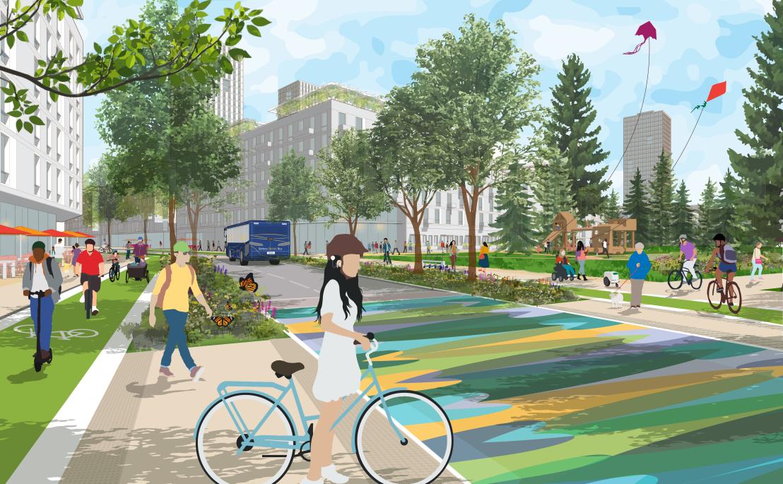
A person with a bike waiting at a decorated crosswalk.
Artistic rendering of Thunderbird Boulevard passing through the vibrant mixed-use centre of the new Acadia Neighbourhood, featuring separated cycle paths, generous sidewalks and transit priority. (Click to open in new tab)

UBC Vancouver in 2050

Two on-campus SkyTrain stations transform the way people get to, from and around campus, better connecting it to the rest of the region. Members of the UBC community who live off campus have shorter, greener, less complicated commutes, giving them more time to study, work, play and rest. On-campus residents benefit from faster and easier transit access to other parts of the region and can easily meet their daily needs without owning a car. With more people arriving by transit, a renewed and expanded on-campus mobility network that prioritizes active and sustainable modes means people of all ages and abilities can get to where they need to go, comfortably and safely, while reducing greenhouse gas emissions. 

Key Strategies

  • Prioritize sustainable modes of transportation, including walking, rolling, cycling and micromobility
  • Enable the extension of SkyTrain to campus with a central station on University Boulevard and a south campus station to serve Wesbrook Place, Stadium Neighbourhood and Hawthorn Place
  • Expand the pedestrian priority zone in the campus core, while preserving access for essential services and accessible parking users
  • Create a safe, legible and efficient cycling and micromobility network to accommodate users of all ages and abilities
  • Build a network of zero-emission local transit/shuttle routes that integrate with regional services, including SkyTrain
  • Design streets and intersections to prioritize the safety and comfort of vulnerable road users, manage congestion and maintain access
  • Reduce the supply of parking, and increase multi-modal transportation infrastructure for both commuters and residents as parking demands decline with more transportation choices formal and informal learning spaces to support grassroots community initiatives and showcase research and discoveries 
Image
Map showing connected campus
The campus transportation network prioritizes active and sustainable modes of transportation and features a locally-serving transit network that connects to future Millennium Line SkyTrain stations. (Click to open in new tab)

Prioritizing Sustainable Modes of Transportation  

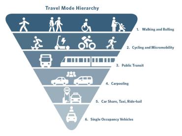
The Vision prioritizes more active and sustainable modes over less sustainable modes (single occupancy vehicles, ride-hailing, taxi, etc.), while ensuring the safety and comfort of more vulnerable road users, such as people walking, rolling, biking or using another form of micromobility.
Image
Infographic showing the travel mode hierarchy.
Image

2050 Active Transportation Network Concept

Image
Example of bike parking
Major cycling hub provides covered bike parking. Photo: Shinagawa City

Walking, rolling and cycling will continue to be the dominant modes of travel for trips around campus in 2050. Cycling and other forms of active transport will become increasingly attractive for trips to and from campus as off-campus infrastructure improves and adoption of e-bikes and other forms of electric micromobility expands. 

On-campus corridors that form part of or provide key links to the Regional Cycling Network will be the focus of investment in cycling facilities for all ages and abilities. A fine-grained, fully accessible and well-lit network of pedestrian pathways will be provided across the campus, punctuated by places and amenities that offer opportunities for respite, weather protection and publicly accessible washroom facilities.

Image
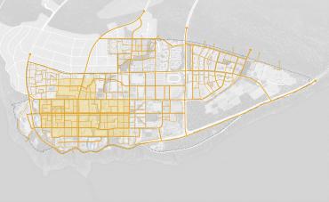
Map showing future active transportation options at UBC
An expanded pedestrian priority zone (shown in the yellow highlighted area) connects to a fine-grained pedestrian network across the campus. (Click to open in new tab)
  • Protected cycling facilities suitable for people of all ages and abilities on major active transportation corridors to, from and around campus
  • A new major cycling hub is envisioned at the central campus SkyTrain station, with state-of-the-art secure parking and end-of-trip facilities and amenities to facilitate seamless intermodal connections and to complement smaller, more distributed bicycle facilities across campus
  • Incorporate multi-modal transportation hubs into community hearts, mixed-use hubs and local nodes, including shared micromobility, transit facilities, accessible parking and pick-up and drop-off areas as applicable
  • Expand shared micromobility options on campus, integrating with systems in neighbouring communities where possible
  • New pedestrian and cycling routes in the future Acadia Neighbourhood, subject to refinement through a future Neighbourhood Plan process

2050 Transit Network Concept

Image
Student showing a compass card in front of a transit stop
UBC Bus Exchange. Photo: Paul H. Joseph

Significant regional investments in transit are expected over the next decades that will dramatically transform UBC. These include:

  • the much-anticipated extension of the Millennium Line SkyTrain by the early 2030s;
  • electrification of bus services;
  • changes to roadways to and from campus to improve transit priority and introduce protected cycling facilities; and
  • eventually, a new rapid transit line connecting the campus to Metrotown via Southwest Marine Drive, 41st and 49th Avenues.

Anticipated behavioral and technological changes include the expanded availability and adoption of shared, electric and autonomous modes of transport, as well as tools to make it easier to plan and pay for multi-modal trips.

Image
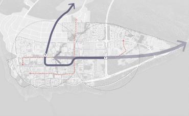
Map of Active Transportation at UBC
Future proposed rapid transit and new on-campus transit routes. (Click to open in new tab)
  • Extend the Millennium Line SkyTrain to campus, with stations in the centre of campus near the Robert H. Lee Alumni Centre and UBC Bus Exchange and in south campus near Stadium and Wesbrook Place Neighbourhoods
  • Introduce two new zero-emission intra-campus local transit services. These services could potentially be delivered by TransLink or as independent transit services:
    • Route 1: north-south service between University Centre/Rose Garden and Wesbrook Village along East Mall and Ross Drive, connecting to both on campus SkyTrain stations
    • Route 2: east-west service between the new Learning Hub in the Arts and Culture District and Acadia Neighbourhood along Lower/West Mall and Thunderbird Boulevard, connecting to a future SkyTrain station in the University Endownment Lands
  • By 2050, upgrade the current R4 Rapid Bus service to rapid transit along 41st and 49th Avenue between UBC and Metrotown 

2050 Functional Street Categories

Image
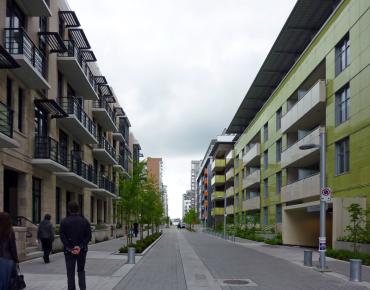
Photo showing city street
Slow traffic neighbourhood street designed for pedestrian priority. Photo: Payton Chung

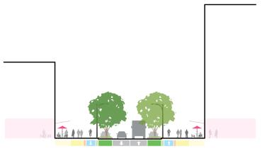
The Vision identifies a network of Complete Streets where all modes of travel are accommodated, Limited Traffic Streets, where only certain motor vehicles are accommodated, and Zero Traffic Streets, where only emergency vehicles are permitted (and transit vehicles on select segments). 

Cars will continue to play a role for trips to, from and around campus, and vehicle access is particularly critical for emergency services, people with mobility challenges, service and delivery vehicles, and ride-hailing and taxi services. The network will be designed to improve safety and minimize congestion, while supporting a transition to fewer car trips.
Image
Diagram showing street design and usage
Illustrative section showing a complete street with a diverse range of uses. (Click to open in new tab)
  • Intersection improvements and transit priority lanes along 16th Avenue and Wesbrook Mall to enhance function and safety
  • Limit vehicle traffic on select streets within the campus core, expanding the Pedestrian Priority Zone, but maintain access for users of accessible parking, service and delivery vehicles, and emergency vehicles
  • Shift to more sustainable last-kilometre delivery to reduce vehicle volumes on local streets and pedestrian-only areas, leveraging new tools, such as automated and/or electric delivery devices  
  • Consolidate neighbourhood parking underground to minimize conflicts with pedestrians and cyclists, support a vibrant public realm and preserve curb space for service and delivery vehicles and passenger pick-up and drop-off
  • Two parkades in the academic core are candidates for redevelopment into mixed-use hubs
  • Explore reduced parking pricing for people without alternatives to driving (e.g., accessibility, off-hour shifts, etc.)